These items were available Tuesday June 14, 2016.
Note:
Prices are subject to change without notice.
Please confirm
details with the office by calling (931)484-5535 or
toll free (866)490-5263.
LOTS FOR SALE
Our current interest rate, based on the 15 year mortgage rate, is 5.4%. Our contracts specify rate adjustment to this index every two years. A "HOLD" usually refers to property that a customer has reserved by paying a small deposit. This is sometimes done because the property is not ready for sale or because the customer needs more time. Either way, no contract has been signed, and the property may well come back on the market.
An asterisk indicates the property could, for example, have a vehicle on it. We sell property. Anything on the property is usually not ours to sell. We will either have requested the owner remove the item or be trying to locate the owner.
The data for the lots is in the following format:
Tract#, Acres, Sale price, Down payment, Payment amount, # of months, comments (if any)
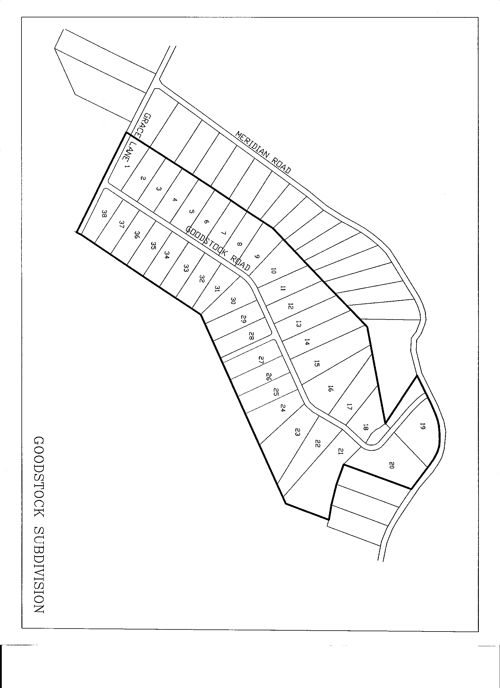
C011H: MERIDIAN 5/GOODSTOCK ROAD – CUMBERLAND COUNTY – Third Civil District. Located in southeastern Cumberland County. Take Hwy 127S to Hwy. 68, go about 3 1/2 miles from Homestead Tower, turn right onto Hayes Road (just past Meridian Baptist), turn left onto Meridian Road, Goodstock is the road on left. City water, gas, mountain views. Recorded plat PB 10, PG 349 click to view. Recorded restrictions in deed book 1046, page 1209. NM Click here for a map of the Meridian area.
#18   2.64 acres    $27,000    $300 down    $216.75/mo   180 mos  MLS #951342
#31   1.79 acres    $26,100    $300 down    $209.44/mo   180 mos  MLS #952765
#32   2.07 acres    $27,000    $300 down    $216.75/mo   180 mos  MLS #952788
#38   1.98 acres    $27,000    $300 down    $216.75/mo   180 mos  MLS #952870
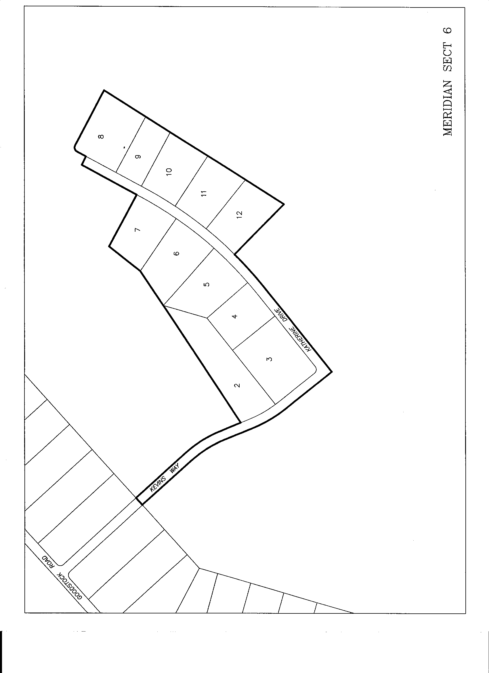
C011J: MERIDIAN 6 – CUMBERLAND COUNTY – Third Civil District. Located in southeastern Cumberland County. Take Hwy 127S to Hwy. 68, go about 3 1/2 miles from Homestead Tower, turn right onto Hayes Road (just past Meridian Baptist), turn left onto Meridian Road, turn left on Goodstock. Meridian 6 is on new road to left. City water, gas, mountain views. Plat recorded plat book 10, page 585, click to view. Restrictions recorded in book 1173, page 1449. NM Click here for a map of the Meridian area.
#05   1.80 acres    $27,000    $300 down    $216.75/mo   180 mos  SOLD
#12   1.72 acres    $27,000    $300 down    $216.75/mo   180 mos  MLS #952887
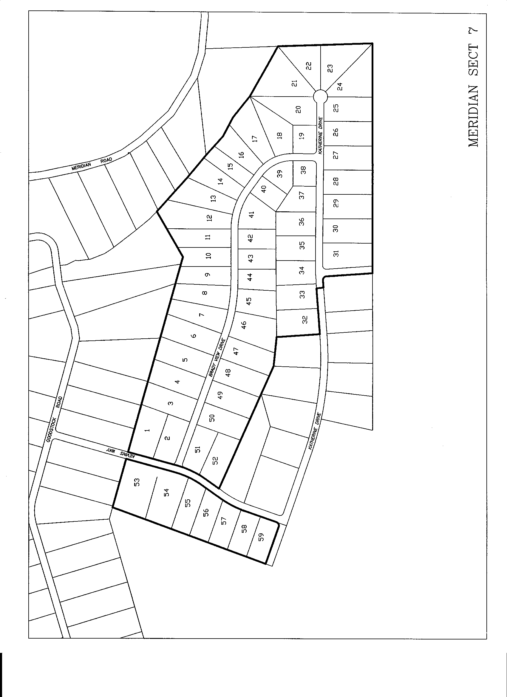
C011K: MERIDIAN 7 – CUMBERLAND COUNTY – Third Civil District. Located in southeastern Cumberland County. Take Hwy 127S to Hwy. 68, go about 3 1/2 miles from Homestead Tower, turn right onto Hayes Road (just past Meridian Baptist), turn left onto Meridian Road, turn left on Goodstock. Turn left onto Kevins Way. Meridian 7 is on new road to left which loops around to Katherine then back to Kevins Way. City water, gas, mountain views. Has a private sewer. Perc tests not needed. Site built homes, 1200 sq ft minimum. The plat is recorded in plat book PL11, pages 7-9 (click to view), and the restrictions book 1249 page 2420. Click here for a map of the Meridian area.
#01   1.49 acres    $36,500    $400 down    $293.05/mo   180 mos  creek
#02   1.17 acres    $20,500    $200 down    $164.79/mo   180 mos  corner
#03   1.42 acres    $34,800    $300 down    $280.07/mo   180 mos  creek
#04   1.47 acres    $20,600    $200 down    $165.60/mo   180 mos
#05   1.52 acres    $21,300    $200 down    $171.29/mo   180 mos
#06   1.57 acres    $22,000    $200 down    $176.97/mo   180 mos
#07   1.39 acres    $19,500    $200 down    $156.67/mo   180 mos
#08   1.27 acres    $17,800    $200 down    $142.87/mo   180 mos
#10   1.04 acres    $14,600    $100 down    $117.71/mo   180 mos
#11   1.27 acres    $17,800    $200 down    $142.87/mo   180 mos
#12   1.89 acres    $36,500    $400 down    $293.05/mo   180 mos  creek
#13   1.53 acres    $36,500    $400 down    $293.05/mo   180 mos  creek
#14   1.38 acres    $29,900    $300 down    $240.29/mo   180 mos  creek
#15   0.98 acres    $24,000    $200 down    $193.21/mo   180 mos  creek
#16   1.22 acres    $29,900    $300 down    $240.29/mo   180 mos  creek
#17   1.53 acres    $21,400    $200 down    $172.10/mo   180 mos
#18   1.66 acres    $23,200    $200 down    $186.71/mo   180 mos SOLD
#19   0.99 acres    $12,600    $100 down    $101.47/mo   180 mos SOLD
#20   1.41 acres    $19,700    $200 down    $158.30/mo   180 mos
#21   1.37 acres    $21,900    $800 down    $171.29/mo   180 mos
#22   1.48 acres    $20,700    $200 down    $166.42/mo   180 mos
#24   1.74 acres    $36,500    $400 down    $293.05/mo   180 mos  mtn_vu
#25   1.45 acres    $30,500    $300 down    $245.16/mo   180 mos
#26   1.47 acres    $30,900    $300 down    $248.41/mo   180 mos  mtn_vu
#27   1.47 acres    $30,900    $300 down    $248.41/mo   180 mos  mtn_vu
#28   1.47 acres    $30,900    $300 down    $248.41/mo   180 mos  mtn_vu
#29   1.47 acres    $30,900    $300 down    $248.41/mo   180 mos  mtn_vu
#30   1.47 acres    $29,400    $600 down    $233.79/mo   180 mos  SOLD
#31   1.51 acres    $26,400    $300 down    $211.88/mo   180 mos  corner
#33   1.11 acres    $15,500    $200 down    $124.20/mo   180 mos
#34   1.08 acres    $15,100    $200 down    $120.96/mo   180 mos
#35   1.06 acres    $21,200    $400 down    $168.85/mo   180 mos  SOLD
#36   1.02 acres    $14,300    $100 down    $115.27/mo   180 mos  SOLD
#37   0.98 acres    $12,600    $100 down    $101.47/mo   180 mos  SOLD
#38   0.83 acres    $12,600    $100 down    $101.47/mo   180 mos  SOLD
#39   0.74 acres    $12,600    $100 down    $101.47/mo   180 mos  SOLD
#40   0.83 acres    $12,600    $100 down    $101.47/mo   180 mos
#41   0.96 acres    $13,400    $100 down    $107.97/mo   180 mos  SOLD
#42   0.92 acres    $12,600    $100 down    $101.47/mo   180 mos
#43   0.92 acres    $12,600    $100 down    $101.47/mo   180 mos
#44   0.92 acres    $12,600    $100 down    $101.47/mo   180 mos
#45   1.09 acres    $15,300    $200 down    $122.58/mo   180 mos  SOLD
#46   1.45 acres    $20,300    $200 down    $163.17/mo   180 mos
#47   1.29 acres    $18,100    $200 down    $145.31/mo   180 mos
#48   1.27 acres    $17,800    $200 down    $142.87/mo   180 mos
#49   1.23 acres    $17,200    $200 down    $138.00/mo   180 mos
#50   1.19 acres    $16,700    $200 down    $133.94/mo   180 mos
#51   1.07 acres    $18,700    $200 down    $150.18/mo   180 mos
#52   1.18 acres    $16,500    $200 down    $132.32/mo   180 mos
#53   2.27 acres    $36,500    $400 down    $293.05/mo   180 mos  creek
#54   1.99 acres    $36,500    $400 down    $293.05/mo   180 mos  creek
#55   1.24 acres    $29,900    $300 down    $240.29/mo   180 mos  creek
#56   1.16 acres    $23,200    $500 down    $184.28/mo   180 mos  SOLD
#57   1.05 acres    $14,700    $100 down    $118.52/mo   180 mos  SOLD
#58   1.04 acres    $14,600    $100 down    $117.71/mo   180 mos
#59   1.08 acres    $18,900    $200 down    $151.80/mo   180 mos  corner
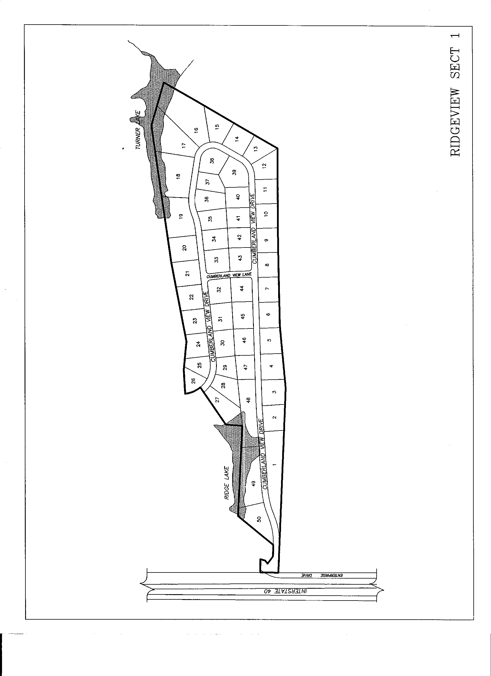
C027R: RIDGE VIEW 1 – CUMBERLAND COUNTY – First Civil District. Take the Peavine Road exit off of I-40 (exit #322) and turn north toward Fairfield Glade. Immediately turn on the first road on the left just past the Nashville on-ramp. Parallel the interstate until it turns to Ridge View. Plat of record plat book 10, page 413 and 414. All underground utilities and some waterfront lots. Lot sales are handled by Brenda Turner of Century 21, 484-6411, [email protected]. Click here to view a plat of Ridge View I. Restrictions recorded in book 1090 page 375-384. Click here for a map of the Ridge View area.
#02   0.86 acres    $23,600    $200 down    $189.96/mo   180 mos
#09   0.80 acres    $31,000    $300 down    $249.22/mo   180 mos
#17   2.04 acres    $75,290    $600 down    $606.32/mo   180 mos
#18   2.13 acres    $65,900    $600 down    $530.10/mo   180 mos
#24   0.85 acres    $21,390  $2,100 down    $156.59/mo   180 mos  SOLD
#25   0.61 acres    $26,700    $300 down    $214.31/mo   180 mos
#26   0.59 acres    $26,700    $300 down    $214.31/mo   180 mos
#27   1.13 acres    $61,100    $600 down    $491.13/mo   180 mos  WATERFRONT
#28   0.84 acres    $28,900    $300 down    $232.17/mo   180 mos
#29   0.64 acres    $22,400    $200 down    $180.22/mo   180 mos
#34   0.79 acres    $40,400    $400 down    $324.71/mo   180 mos
#35   0.83 acres    $40,400    $400 down    $324.71/mo   180 mos
#36   0.89 acres    $45,200    $500 down    $362.87/mo   180 mos
#37   0.68 acres    $45,200    $500 down    $362.87/mo   180 mos
#40   0.75 acres    $40,400    $400 down    $324.71/mo   180 mos
#41   0.73 acres    $39,200    $400 down    $314.97/mo   180 mos
#42   0.71 acres    $28,900    $300 down    $232.17/mo   180 mos
#43   0.79 acres    $40,400    $400 down    $324.71/mo   180 mos  corner
#46   0.82 acres    $35,600    $400 down    $285.75/mo   180 mos
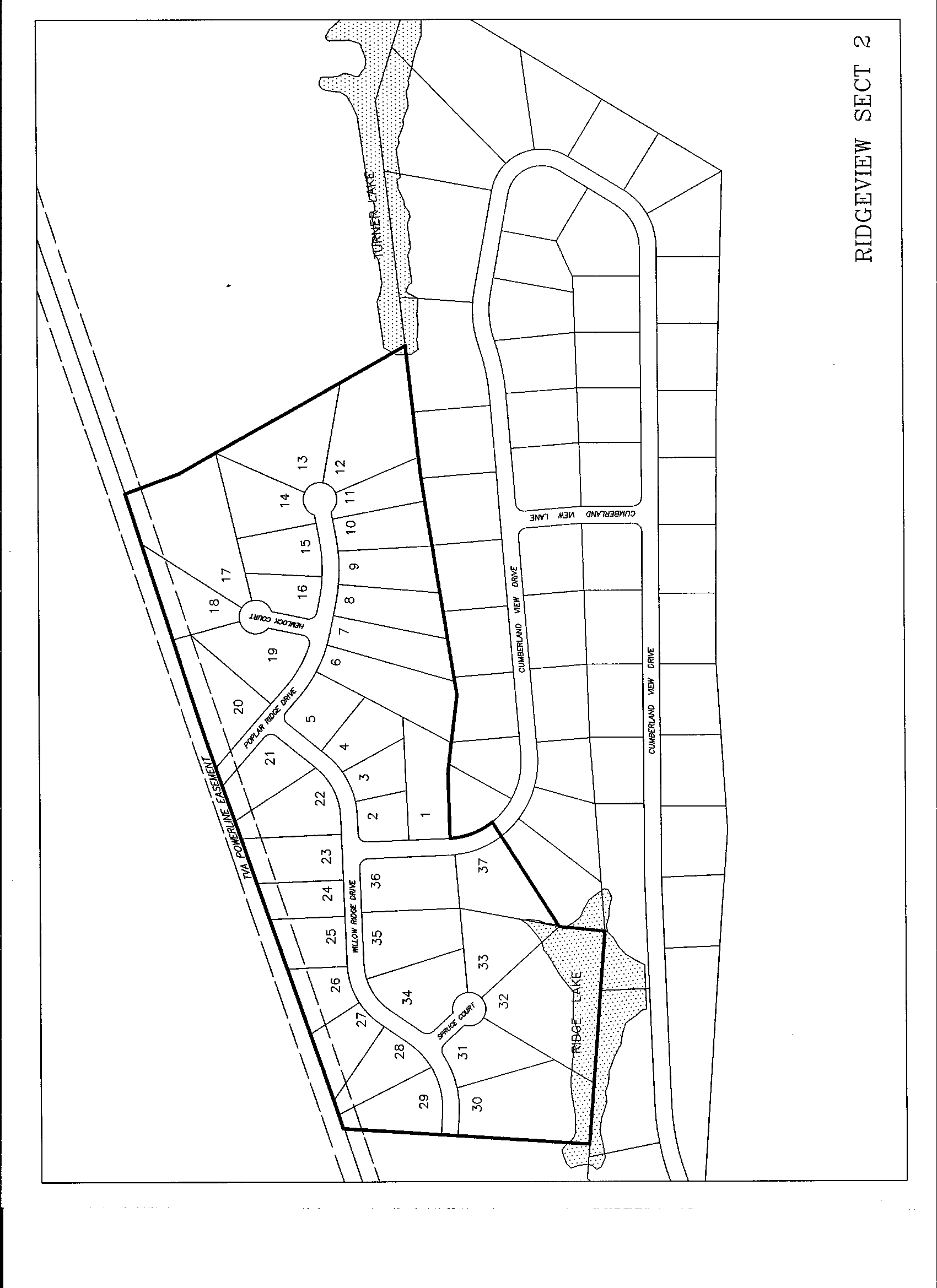
C027S: RIDGE VIEW 2 – CUMBERLAND COUNTY – First Civil District. Take the Peavine Road exit off of I-40 (exit #322) and turn north toward Fairfield Glade. Immediately turn on the first road on the left just past the Nashville on-ramp. Parallel the interstate until it turns to Ridge View. Continue on Cumberland View Drive until you enter the new part. Plat of record platbook 11, page 145. All underground utilities and some waterfront lots. Lot sales are handled by Brenda Turner of Century 21, 484-6411, [email protected]. Click here to view a plat of Ridge View II. Restrictions recorded in book 1286 page 861. Click here for a map of the Ridge View area.
#01   0.90 acres    $37,400    $400 down    $300.36/mo   180 mos
#02   0.49 acres    $23,300    $200 down    $187.52/mo   180 mos  CORNER
#03   0.49 acres    $20,700    $200 down    $166.42/mo   180 mos
#04   0.68 acres    $27,900    $300 down    $224.05/mo   180 mos
#05   0.68 acres    $31,500    $300 down    $253.28/mo   180 mos  CORNER
#06   1.20 acres    $31,500    $300 down    $253.28/mo   180 mos
#07   0.86 acres    $29,700    $300 down    $238.67/mo   180 mos
#08   0.80 acres    $28,800    $300 down    $231.36/mo   180 mos
#09   0.75 acres    $28,800    $300 down    $231.36/mo   180 mos
#10   0.74 acres    $28,800    $300 down    $231.36/mo   180 mos
#11   0.61 acres    $36,900    $400 down    $296.30/mo   180 mos  CUL-DE-SAC
#12   1.89 acres    $95,300  $1,000 down    $765.51/mo   180 mos  LAKE
#13   1.34 acres    $67,500    $700 down    $542.27/mo   180 mos  CUL-DE-SAC
#17   2.11 acres    $31,500    $300 down    $253.28/mo   180 mos  CUL-DE-SAC
#18   0.90 acres    $22,500    $200 down    $181.03/mo   180 mos  CUL-DE-SAC
#19   1.04 acres    $43,200    $400 down    $347.44/mo   180 mos  CORNER
#20   1.21 acres    $27,900    $300 down    $224.05/mo   180 mos
#21   0.79 acres    $22,500    $200 down    $181.03/mo   180 mos  CORNER
#22   0.95 acres    $18,900    $200 down    $151.80/mo   180 mos
#23   0.86 acres    $18,900    $200 down    $151.80/mo   180 mos
#24   0.61 acres    $18,900    $200 down    $151.80/mo   180 mos
#25   0.71 acres    $18,900    $200 down    $151.80/mo   180 mos
#26   0.61 acres    $18,900    $200 down    $151.80/mo   180 mos
#27   0.73 acres    $18,900    $200 down    $151.80/mo   180 mos
#28   0.78 acres    $18,900    $200 down    $151.80/mo   180 mos
#29   0.88 acres    $18,900    $200 down    $151.80/mo   180 mos
#30   1.79 acres    $77,300    $800 down    $621.02/mo   180 mos  WATERFRONT
#31   0.81 acres    $59,300    $600 down    $476.52/mo   180 mos  CORNER
#33   0.97 acres    $77,300    $800 down    $621.02/mo   180 mos  WATERFRONT
#34   1.04 acres    $46,700    $500 down    $375.05/mo   180 mos  CORNER
#35   1.04 acres    $31,500    $300 down    $253.28/mo   180 mos
#36   1.11 acres    $32,400    $300 down    $260.58/mo   180 mos  CORNER
#37   1.05 acres    $77,400    $800 down    $621.83/mo   180 mos  WATERFRONT
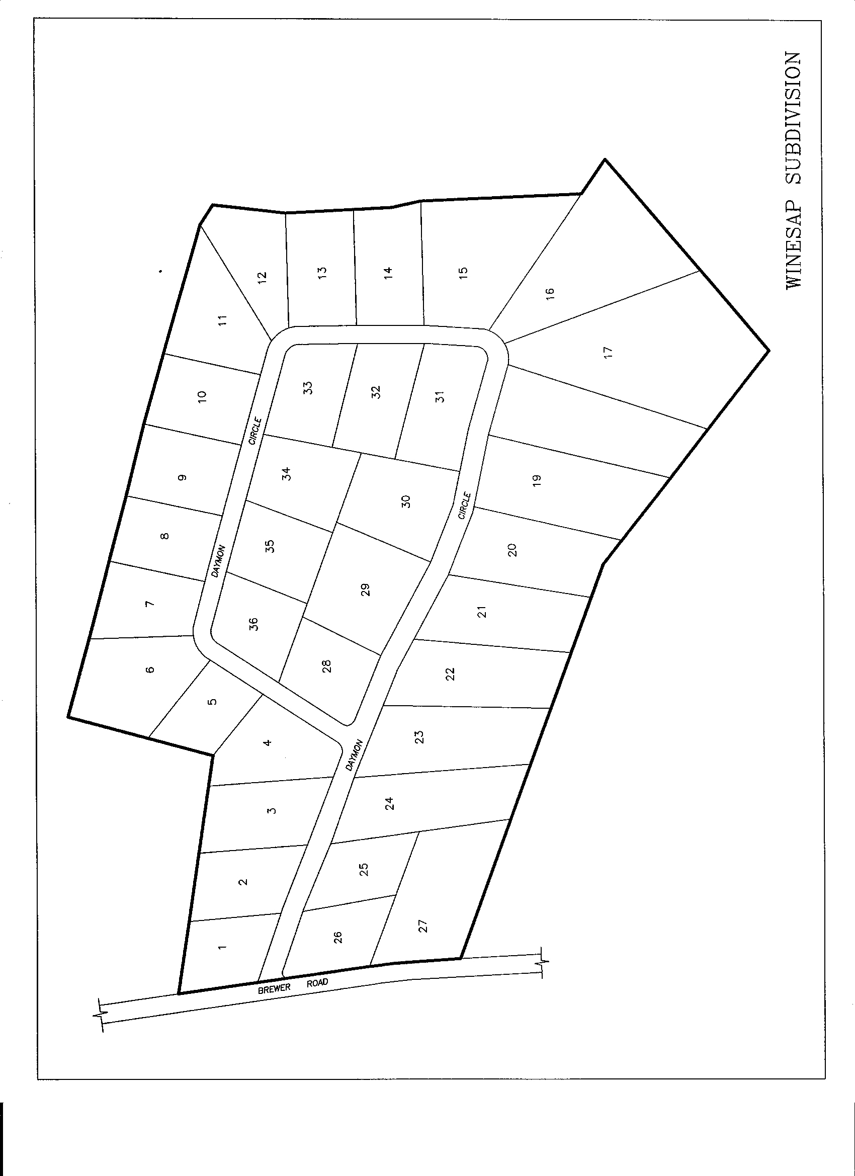
C064J: WINESAP SUBDIVISION – VANDEVER, CUMBERLAND COUNTY – Fifth Civil District. Located in southwestern Cumberland County. Take Lantana Road to Vandever Road, go about 5 miles, turn right at Vandever Corner Grocery onto Brewer Road, go about 3 1/2 miles, turn right onto Daymon Circle. To view a plat of Daymon Circle, click here. Light restrictions, city water, gas, paved road. Recorded plat in Plat Book 10, Page 268. Also see Plat Book 11, page 403 for lots #11 through lot #14. M Click here for a map of the Vandever area.
#11   2.35 acres    $20,000    $800 down    $155.86/mo   180 mos  SOLD
#12   1.02 acres    $16,200    $200 down    $129.89/mo   180 mos  SOLD
#13   1.02 acres    $18,000    $360 down    $143.20/mo   180 mos  SOLD
#14   1.02 acres    $18,000    $360 down    $143.20/mo   180 mos  SOLD
#16   2.83 acres    $25,000    $500 down    $198.89/mo   180 mos  SOLD
#22   1.77 acres    $13,050    $200 down    $104.31/mo   180 mos
#24   1.80 acres    $14,250    $400 down    $112.43/mo   180 mos  SOLD
#27   2.08 acres    $16,000    $200 down    $128.26/mo   180 mos
#35   1.28 acres    $10,800    $100 down     $86.86/mo   180 mos  SOLD
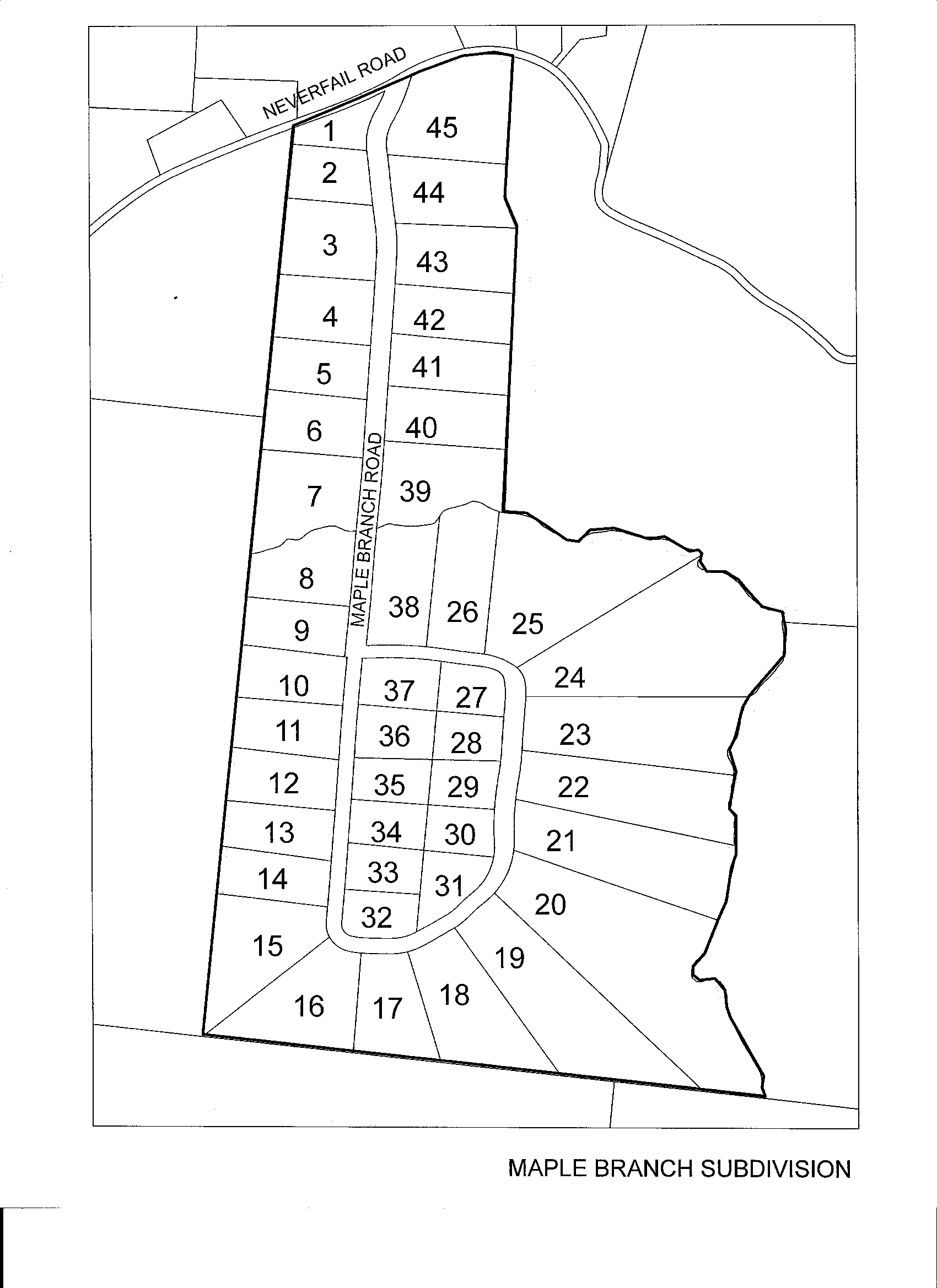
C073-: MAPLE BRANCH ROAD – PLEASANT HILL AREA – CUMBERLAND COUNTY - Eighth Civil District. Located in western Cumberland County. From Kroger's or K-Mart in Crossville, take Hwy 70 S toward Sparta about 12 miles to Neverfail Road, turn right, and go 1.8 miles. Maple Branch turns right off of Neverfail Road. City water, gas, paved road. Light restrictions. To view a plat of Maple Branch click here. This plat is recorded in Plat Book 10, Page 5. M Click here for a map of the Maple Branch area.
#42 2.10 acres $25,000 $400 down $199.70/mo 180 mos creek / partial clearing
CGEHCL: CLARINGTON PARK – CUMBERLAND COUNTY – First Civil District. Located southwest of Crossville - Take Lantana Road to Dunbar, Clarington will be on right of Dunbar Road. Restricted, all underground utilities, paved roads, wooded, very convenient to town. Lot #7 is an unusually large tract in an unusually upscale area. Lot sales are handled by Brenda Turner of Century 21, 484-6411, [email protected]. Click here for a map of the Clarington Park area.
#07   5.30 acres    $58,800    $600 down    $472.46/mo   180 mos
#15   2.20 acres    $34,100    $300 down    $274.38/mo   180 mos
#16   2.40 acres    $34,100    $300 down    $274.38/mo   180 mos
#20   3.30 acres    $34,100    $300 down    $274.38/mo   180 mos
#26   1.80 acres    $28,700    $300 down    $230.55/mo   180 mos
CJJBCH: MCGINNIS FORD/DADDY'S CREEK – EASTERN CUMBERLAND COUNTY – Fourth Civil District. Located just north of where I-40 crosses over Daddy's Creek. A part of the Obed Wild & Scenic River. For someone seeking exceptional privacy and pristine natural beauty. Good road most of way in through a gated pine plantation. No utilities. Historic Ford. Large old hardwood timber. You must see us to visit the property as it's past a locked gate. Just south of the Peavine Road and I-40 interchange, turn east by Chestnut Hill Winery onto Chestnut Hill Rd. Follow it 5.2 miles. Turn right onto McGinnis Road. Go 0.8 miles south to locked gate. Go through gate, continue 0.5 miles further and turn left. Go to end. Property begins there. A foot path continues through the property to Daddy's Creek. Click here for a map of the McGinnis Ford / Daddy's Creek area.
#01 60.00 acres $180,000 $1,800 down $1446.60/mo 180 mos
CPLAPL: THE PLANTATIONS – CUMBERLAND COUNTY – First Civil District. Located southwest of Crossville - Take Lantana Road to Dunbar, Plantations will be on right of Dunbar Road at white picket fencing. Restricted, all underground utilities, paved road, wooded, oversize lots, convenient to town. A stable is allowed. Click here for a map of the Plantations area.
#03 8.68 acres $85,000 $900 down $682.71/mo 180 mos
F002A: GATEWOOD FORD I –- FENTRESS COUNTY –- Fifth Civil District. From just north of the Jamestown Municipal Airport on highway 127, turn east on Owens Road and go 1.9 miles to a tee. Turn right onto Tinchtown Road. Go 1.8 miles to Ray's Market and continue straight (road turns into Gatewood Ford Road). Go 2.5 miles. Area is on the right. You should see the "Shotgun Annie" road sign. To view a plat of Gatewood Ford, click here. This plat is recorded in book P4, page 91. Light restrictions (mobile allowed) recorded book 62, page 494. City water. NM Click here for a map of the Gatewood Ford area.
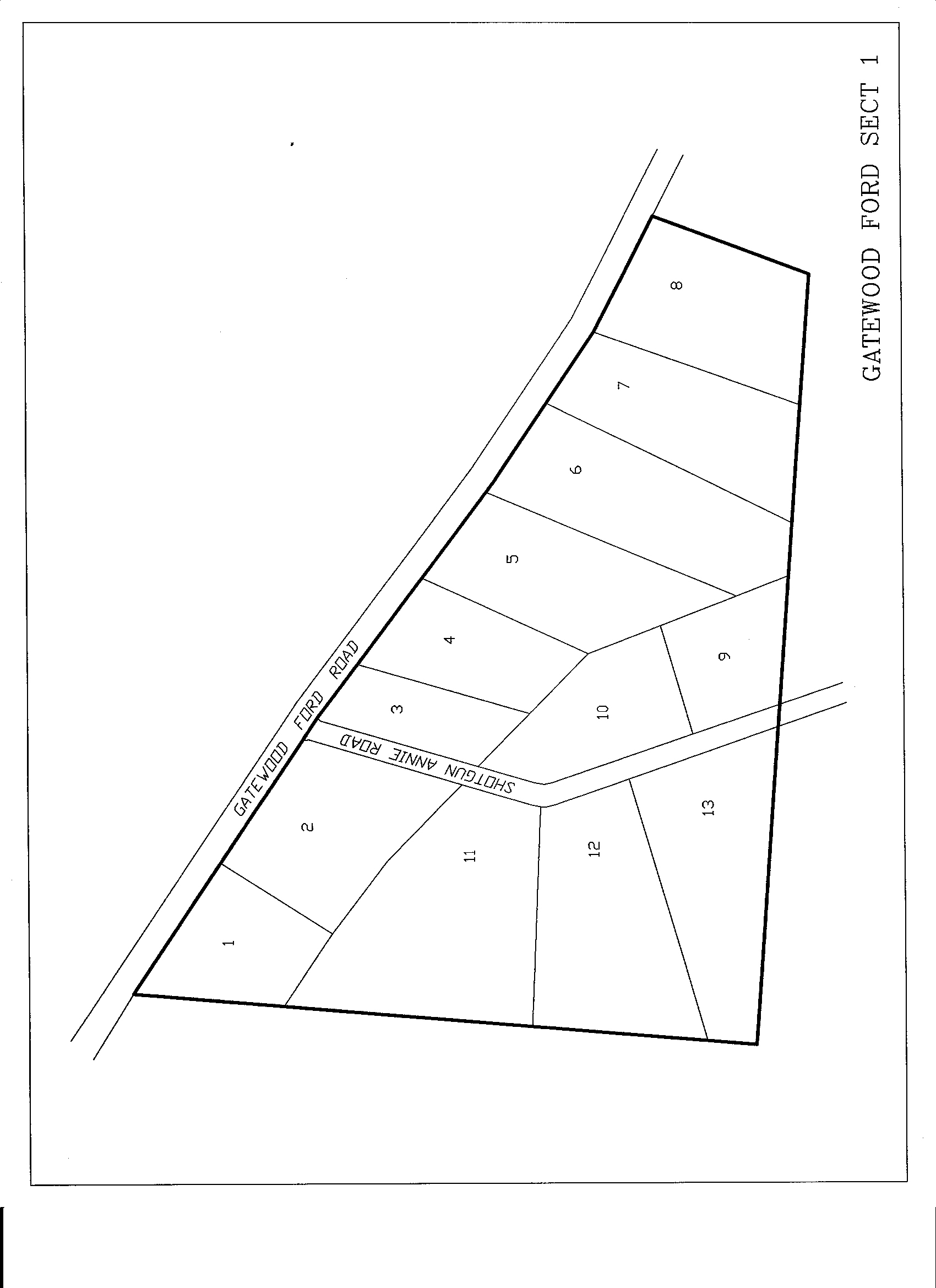
#05   2.13 acres    $16,200    $200 down    $129.89/mo   180 mos
#06   2.44 acres    $16,200    $200 down    $129.89/mo   180 mos  SOLD
#07   2.31 acres    $16,200    $200 down    $129.89/mo   180 mos  SOLD
M019-: TWIN BRIDGE FARMS – MORGAN COUNTY – Seventh Civil District. Located in western Morgan County near the Fentress County line. Take hgy. 127N to hgy. 62E at Clarkrange, turn right, go eight miles, turn left onto Abigail Trail at the Twin Bridge Farms sign. Click to view plat. Some restrictions, mobile homes allowed (12x60), farm animals fenced to rear, no commercial. Paved road, city water. NJ NM Click here for a map of the Twin Bridge Area.
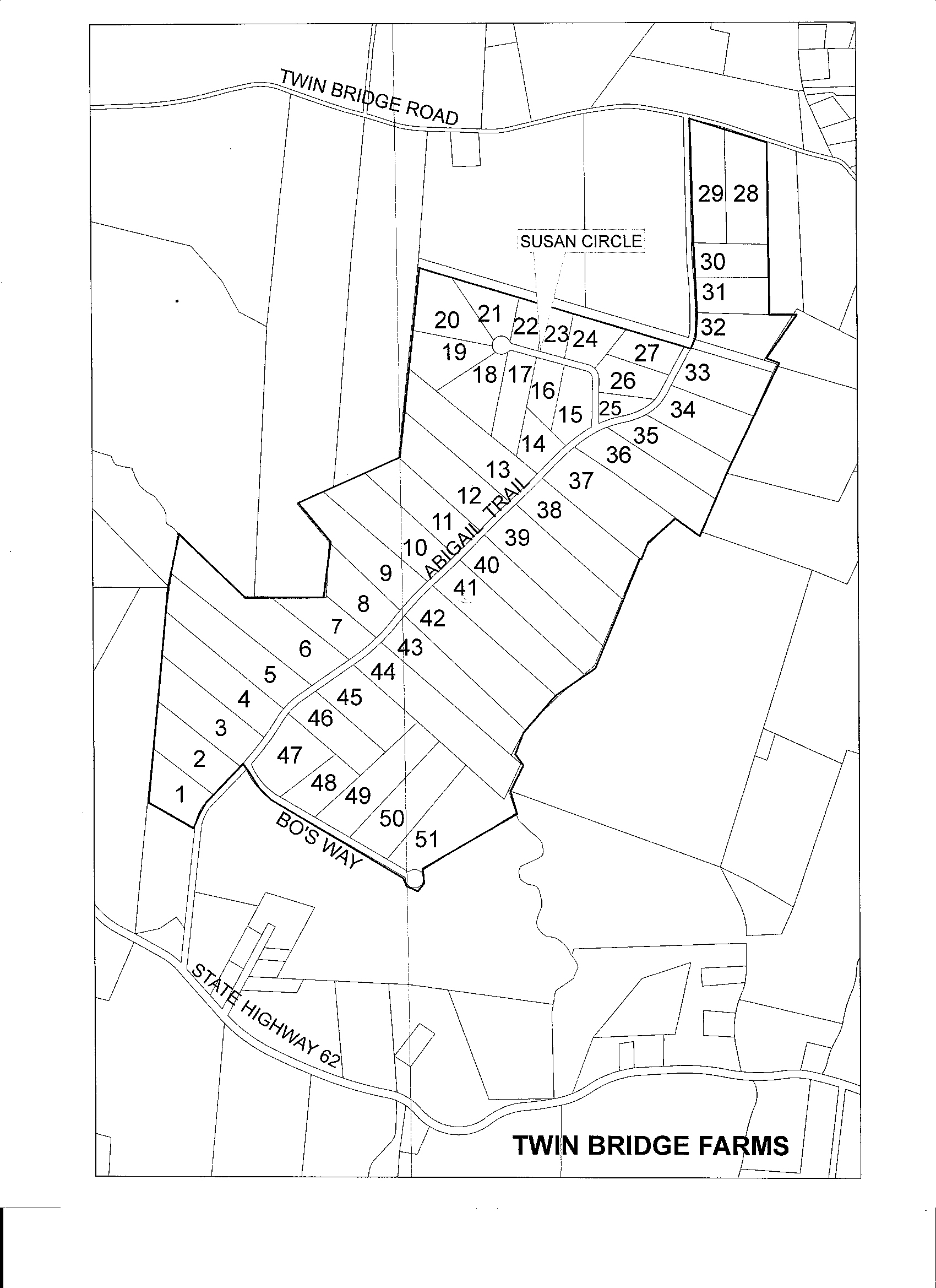
#03   6.22 acres    $35,000    $750 down    $278.04/mo   180 mos SOLD
#04   7.82 acres    $35,000    $750 down    $278.04/mo   180 mos
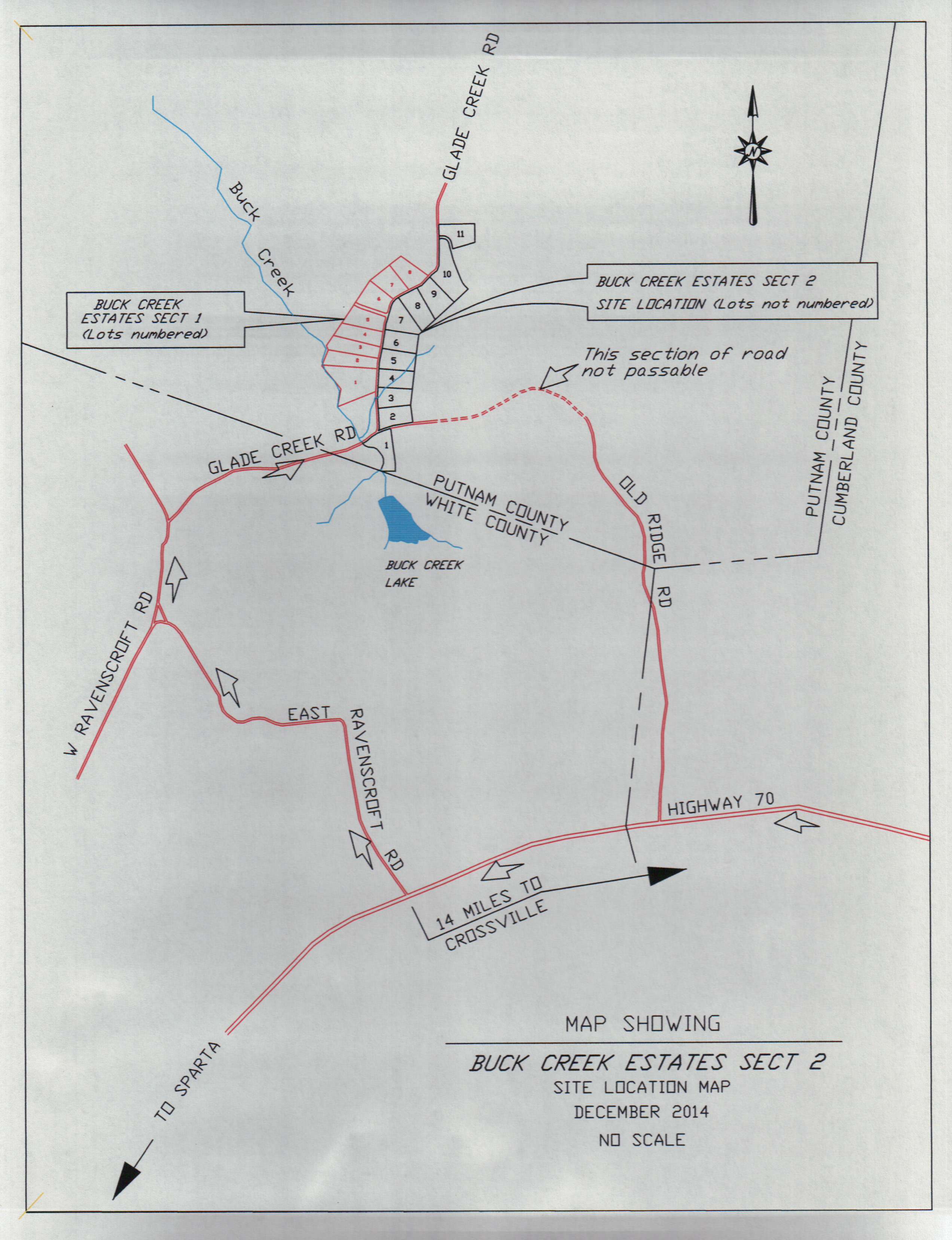
P001C: BUCK CREEK ESTATES 2 - PUTNAM CO. - 4th Civil District. Located in eastern Putnam County near where Cumberland, White, and Putnam Counties meet on Glade Creek Road. Beginning in Cumberland County, head west on highway 70 toward Sparta. Shortly after crossing into White County, turn right onto East Ravenscroft Road. Continue until it runs into Glade Creek Road. As soon as you cross into Putnam County, the property is on the right. Light restrictions. Plat is of record in Putnam County register's office, plat cabinet H page 51B. Click to view plat. Here is a little map to help you find your way: Click to view directions to area. NM
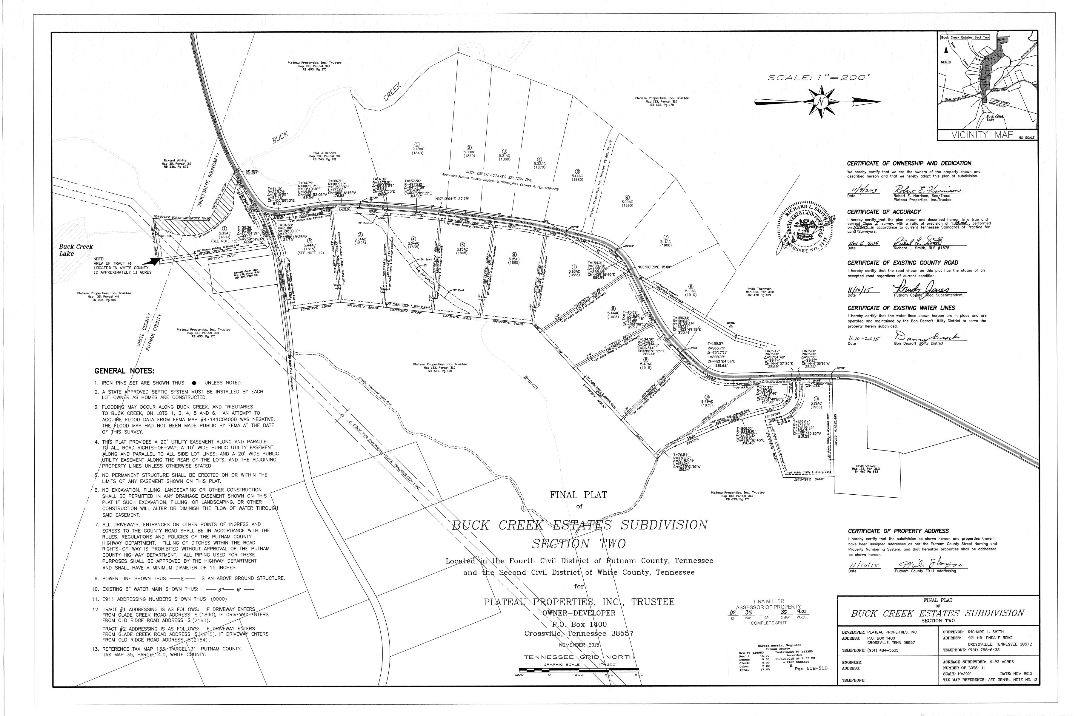
#01   5.33 acres    $25,000    $250 down    $200.92/mo   180 mos creek
#02   5.44 acres    $20,000    $200 down    $160.73/mo   180 mos SOLD
#03   5.04 acres    $35,000    $700 down    $278.44/mo   180 mos
#04   5.04 acres    $35,000    $700 down    $278.44/mo   180 mos
#05   5.15 acres    $25,500    $260 down    $204.89/mo   180 mos SOLD
#06   5.15 acres    $20,800    $300 down    $166.42/mo   180 mos SOLD
#07   5.60 acres    $22,400    $220 down    $180.05/mo   180 mos SOLD
#08   5.44 acres    $22,000    $220 down    $176.81/mo   180 mos SOLD
#09   5.42 acres    $22,000    $220 down    $176.81/mo   180 mos SOLD
#10   8.49 acres    $32,400    $320 down    $260.42/mo   180 mos SOLD
#11   5.13 acres    $20,400    $200 down    $163.98/mo   180 mos
P002C: GLADE CREEK - PUTNAM CO. - 4th Civil District. Located in eastern Putnam County near where Cumberland, White, and Putnam Counties meet. Take Highway 70N to Mayland, turn left onto Mayland Pleasant Hill Road, go 1 1/2 miles, turn right onto Cow Pen Road, go to end and turn right onto Glade Creek Road, go 8/10th of a mile. Property is on the right. Gas and city water are available on Glade Creek Road.
#06 9.43 acres $32,400 $600 down $258.15/mo 180 mos
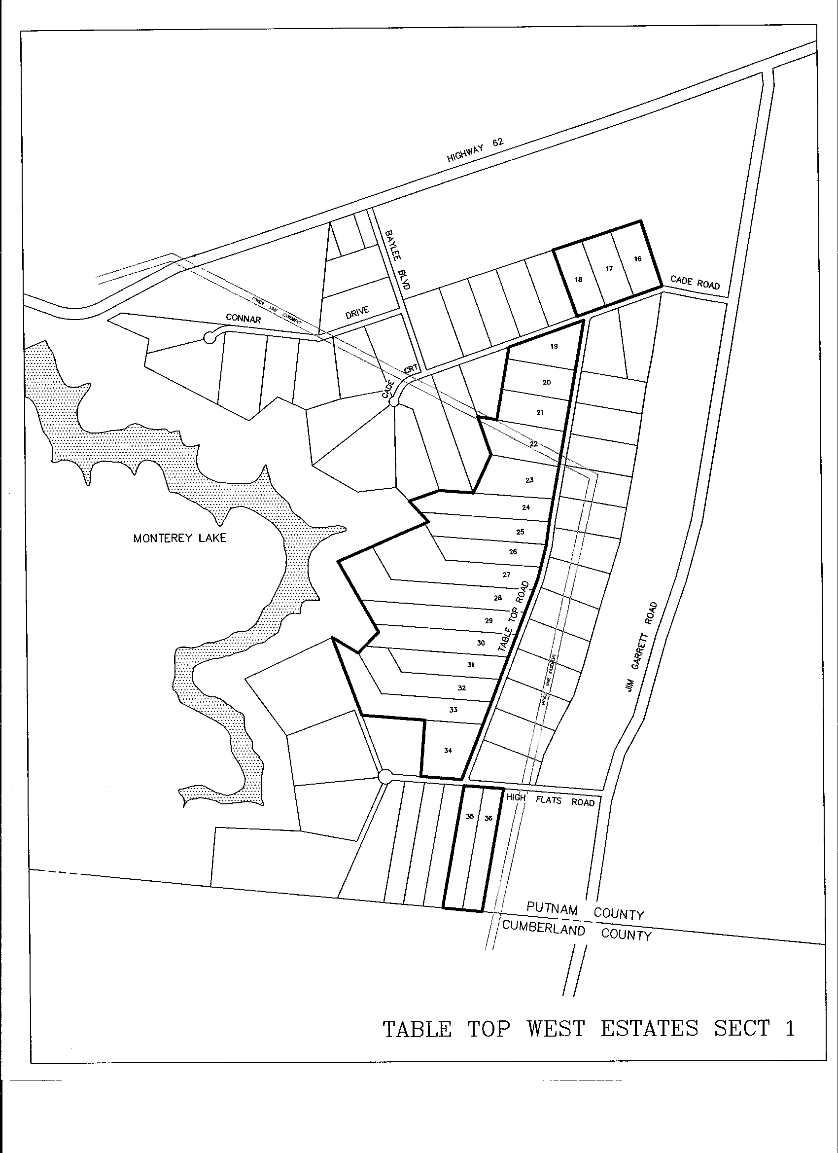
P009D: TABLE TOP WEST I – PUTNAM CO. – 14th Civil District. Located in eastern Putnam County. Take exit 300 off I-40 and go into Monterey. Take Hwy 62E heading east from Monterey 7.0 miles to Jim Garrett Road, turn right and go south 0.7 miles. Turn right onto Cade Road.
From I-40 exit 311 (Plateau Road), go 1.4 miles south to highway 70. Turn right and go 1.8 miles to Mayland Loop. Turn right and follow loop 0.1 miles to Jim Garrett Road. Turn right on Jim Garrett and continue 4.4 miles to High Flats on the left. Note that High Flats Road runs into Table Top Road on the south end, and Cade Road runs into Table Top Road on the north end. Tracts are on the west side (left coming from Mayland). Putnam County Plat Book cabinet D, slide 42. Click to view plat. Some restrictions. No single wides allowed. Dwellings must be on a permanent foundation and have 1400 sq ft. Horses are allowed. City water. Restrictions deed book 442 page 669. NJ M Click here for a map of the Table Top area.
#17   5.06 acres    $32,590    $500 down    $260.50/mo   180 mos  SOLD
#19   5.10 acres    $29,590    $490 down    $236.23/mo   180 mos  SOLD
#20   5.10 acres    $24,090    $400 down    $192.31/mo   180 mos  SOLD
#21   5.10 acres    $25,000    $500 down    $198.89/mo   180 mos  SOLD
#23   7.82 acres    $40,400    $400 down    $324.71/mo   180 mos  SOLD
#24   7.00 acres    $42,590    $700 down    $340.06/mo   180 mos  SOLD
#26   5.74 acres    $34,100    $300 down    $274.38/mo   180 mos  SOLD
#27  11.80 acres   $106,200  $1,100 down    $853.19/mo   180 mos
#28  12.30 acres   $111,400  $1,100 down    $895.40/mo   180 mos
#29   8.13 acres    $44,900    $740 down    $358.48/mo   180 mos  SOLD
#30   7.55 acres    $50,900    $830 down    $406.46/mo   180 mos  SOLD
#31   5.78 acres    $31,500    $600 down    $250.84/mo   180 mos
#35   5.76 acres    $26,900    $400 down    $215.12/mo   180 mos  SOLD
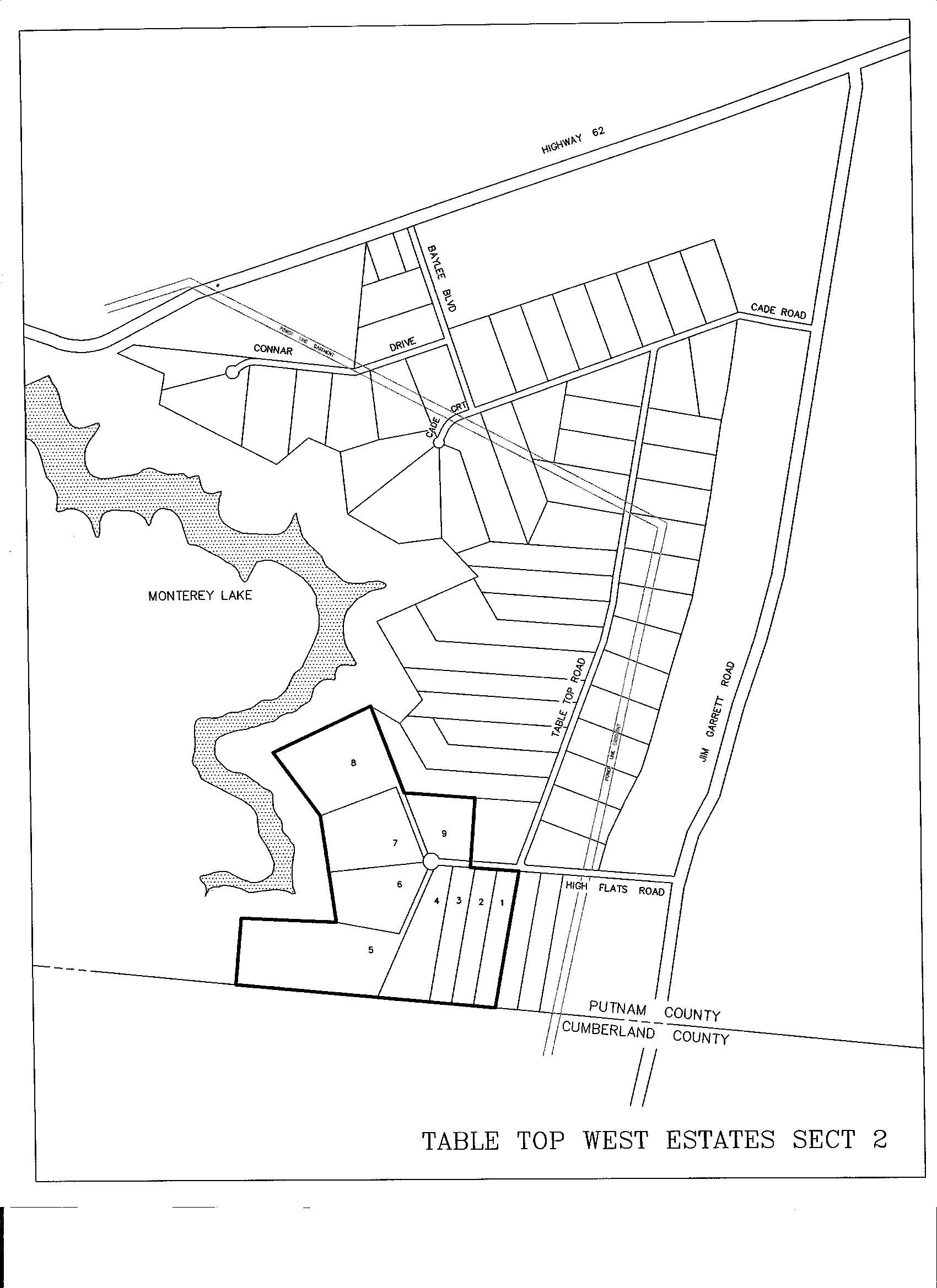
P009E: TABLE TOP WEST II – PUTNAM CO. – 14th Civil District. Located in eastern Putnam County. Take exit 300 off I-40 and go into Monterey. Take Hwy 62E heading east from Monterey 7.0 miles to Jim Garrett Road, turn right and go south 0.7 miles. Turn right onto Cade Road. Follow Cade to Table Top and turn left. Head south until Table Top tees at High Flats. Turn right onto High Flats.
From I-40 exit 311 (Plateau Road), go 1.4 miles south to highway 70. Turn right and go 1.8 miles to Mayland Loop. Turn right and follow loop 0.1 miles to Jim Garrett Road. Turn right on Jim Garrett and continue 4.4 miles to High Flats on the left. Continue on High Flats past intersection with Table Top. Putnam County plat book cabinet D page 91B. Click to view plat. City water. Restrictions of record in book 153 page 710. Click here for a map of the Table Top area.
#05  20.32 acres   $130,600  $1,300 down   $1049.64/mo   180 mos bluff
#06   9.36 acres    $66,990  $1,000 down    $535.70/mo   180 mos SOLD
#08  15.57 acres    $98,600  $1,000 down    $792.30/mo   180 mos bluff
#09   6.41 acres    $32,300    $300 down    $259.77/mo   180 mos SOLD
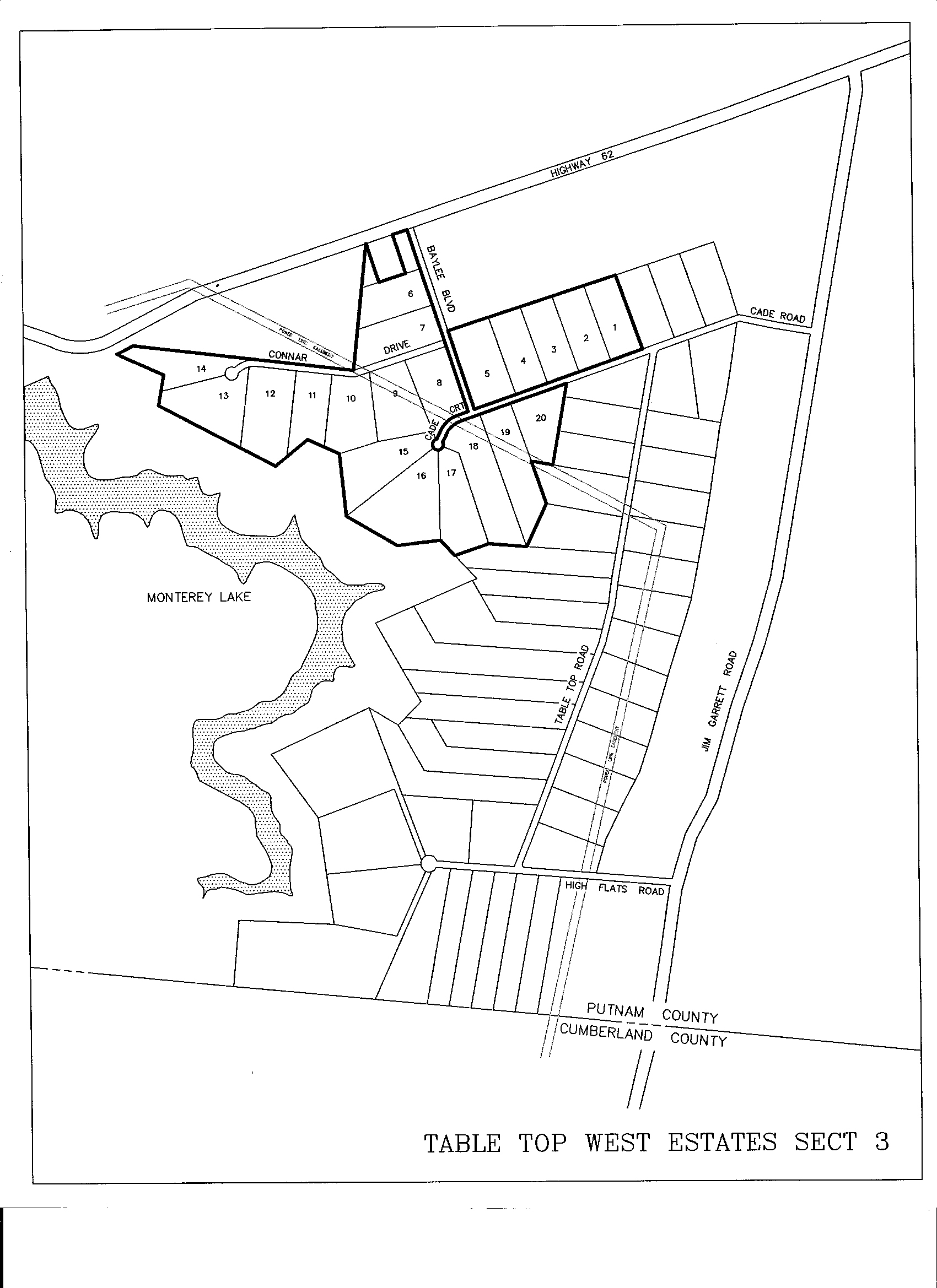
P009F: TABLE TOP WEST III – PUTNAM CO. – 14th Civil District. Located in eastern Putnam County. Take exit 300 off I-40 and go into Monterey. Take Hwy 62E heading east from Monterey 7.0 miles to Jim Garrett Road, turn right and go south 0.7 miles. Turn right onto Cade Road. Follow Cade past the intersection with Table Top.
From I-40 exit 311 (Plateau Road), go 1.4 miles south to highway 70. Turn right and go 1.8 miles to Mayland Loop. Turn right and follow loop 0.1 miles to Jim Garrett Road. Turn right on Jim Garrett and continue 4.4 miles to High Flats on the left. Continue on High Flats and turn right at Table Top. Proceed on Table Top to Cade and turn left. Plat recorded in cabinet D, slide 164A. Click to view plat of Table Top III. City water. Restrictions are recorded in book 162, page 569. Click here for a map of the Table Top area.
#01   5.10 acres    $34,000    $600 down    $271.14/mo   180 mos SOLD
#03   5.10 acres    $34,000    $600 down    $271.14/mo   180 mos SOLD
#04   5.10 acres    $31,500    $300 down    $253.28/mo   180 mos
#06   5.18 acres    $31,500    $300 down    $253.28/mo   180 mos SOLD
#09   6.91 acres    $34,200    $300 down    $275.20/mo   180 mos SOLD
#10   5.98 acres    $41,600    $400 down    $334.46/mo   180 mos SOLD
#11   5.41 acres    $40,500    $400 down    $325.53/mo   180 mos SOLD
#12   7.15 acres    $43,500    $400 down    $349.88/mo   180 mos SOLD
#14   5.62 acres    $30,900    $300 down    $248.41/mo   180 mos SOLD
#15   7.27 acres    $48,290    $800 down    $385.52/mo   180 mos SOLD
#18   9.09 acres    $53,790    $800 down    $430.17/mo   180 mos SOLD
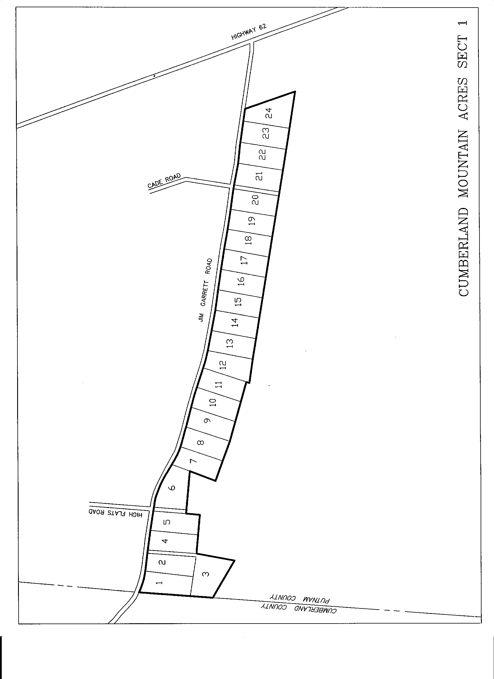
P009G: CUMBERLAND MOUNTAIN ACRES I – PUTNAM CO. – 14th Civil District. Located in eastern Putnam County. Take hgwy. 62E from Monterey heading east 7 miles to Jim Garrett Road. Turn right. Go one tenth mile. The property lies along the left (east) side of the road.
From I-40 exit 311 (Plateau Road), go 1.4 miles south to highway 70. Turn right and go 1.8 miles to Mayland Loop. Turn right and follow loop 0.1 miles to Jim Garrett Road. Turn right on Jim Garrett and continue 4.2 miles until you cross the county line. The property is on the right (east) side of the road. Plat recorded in Cabinet E page 72A. Click here to view plat of Cumberland Mountain Acres . City water. Restrictions recorded in book 319, page 350. City water. NJ NM Click here for a map of the Cumberland Mountain Acres area.
#01   5.54 acres    $30,430    $750 down    $240.94/mo   180 mos  SOLD
#02   5.04 acres    $26,300    $300 down    $211.06/mo   180 mos
#03   7.82 acres    $41,100    $400 down    $330.40/mo   180 mos  SOLD
#04   5.11 acres    $31,015    $750 down    $245.69/mo   180 mos  SOLD
#05   5.10 acres    $28,800    $300 down    $231.36/mo   180 mos  SOLD
#06   6.34 acres    $35,000    $400 down    $280.88/mo   180 mos  SOLD
#07   5.09 acres    $29,260    $700 down    $231.85/mo   180 mos  SOLD
#08   5.16 acres    $29,845    $700 down    $236.60/mo   180 mos  SOLD
#09   5.24 acres    $29,260    $700 down    $231.85/mo   180 mos  SOLD
#10   5.26 acres    $29,260    $700 down    $231.85/mo   180 mos  SOLD
#11   5.20 acres    $29,260    $700 down    $231.85/mo   180 mos  SOLD
#12   5.24 acres    $41,100    $400 down    $330.40/mo   180 mos  SOLD
#13   5.14 acres    $29,845    $700 down    $236.60/mo   180 mos  SOLD
#14   5.11 acres    $30,700    $300 down    $246.78/mo   180 mos  SOLD
#15   5.12 acres    $34,108    $800 down    $270.39/mo   180 mos  SOLD
#16   5.17 acres    $30,700    $300 down    $246.78/mo   180 mos
#17   5.20 acres    $30,000    $600 down    $238.67/mo   180 mos  SOLD
#18   5.10 acres    $30,700    $300 down    $246.78/mo   180 mos
#19   5.13 acres    $34,108    $800 down    $270.39/mo   180 mos  SOLD
#20   5.23 acres    $30,700    $300 down    $246.78/mo   180 mos
#22   5.40 acres    $35,446    $800 down    $281.25/mo   180 mos  SOLD
#23   5.47 acres    $31,015   $1000 down    $243.66/mo   180 mos
#24   6.35 acres    $36,700    $400 down    $294.68/mo   180 mos  SOLD
Tracts not priced may be sold out or have road construction to be completed. Please call for current information.